The southern part
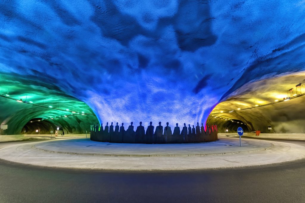
With an area of 286.9 km², Eysturoy is the second largest island in the Faroe Islands. The island is connected to Streymoy by the bridge crossing the sound at Norðskáli. From here, the Norðskála Tunnel connects the western side of Eysturoy with the eastern side and further with the northern part of the island. A subsea tunnel, Norðoyatunnilin, from Leirvík to Klaksvík connects Eysturoy with Borðoy, and at the end of 2020, the subsea tunnel, Eysturoyartunnilin, from Tórshavn to Eysturoy was also opened. Inside the tunnel is a roundabout with exits to both Saltnes, Strendur and Tórshavn. Eysturoy has thus become a very central island. The roundabout, which is said to be the world’s first in an undersea tunnel, features a work of art by Tróndur Patursson.
The fjord lies on the southern side of the island, and on the eastern side lies Fuglafjørður, Gøtuvík and Leirvík where large port facilities have been built. It is not possible to build port facilities in the villages of Lamba, Rituvík and Æðuvík. The large companies are therefore concentrated in Skálafjørður, Fuglafjørður, Leirvík and Gøta as evinced by the local demographics. These villages have grown, while others have stagnated or simply serve as residential towns.
By Skálafjørður, the country’s longest fjord, the highest points are the mountains Støðlafjall and Stórafjall at 517 m and 567 m, respectively. Skálafjørður was previously called Kongshavn, where the municipalities since 1914 have been collaborating in respect of port of Kongshavnar based on a distribution key on rights, responsibilities and income for the individual municipalities.
The markatal settlements of Strendur, Skáli, Søldarfjørður, Glyvrar, Toftir and Nes are located by Skálafjørður. The area also includes the outlying villages of Runavík and Saltangará, which have merged together with Glyvrar, Lambareiði, Gøtueiði and Skipanes.
The Faroe Island’s fourth largest lake, Toftavatn, is located in the border area between Glyvrar and Toftir. The flat heather-covered area around Toftavatn has a rich bird life. In this area, Runavíkar and Nes Kommuna have together laid a footpath called Sóljuleiðir around large parts of Toftavatn. An ancient legend about Nykurin, the water horse or the nix, has been associated with the lake. The supernatural creature assumes various forms and attempts to lure the unsuspecting to touch its tail, after which they cannot escape and are dragged under the water and drowned.
On the west side towards Streymoy lies the markatal settlement of Selatrað and the two smaller outlying villages of Kolbeinagjógv and Morskranes.
Gøta’s settlement is located mainly on the east side at Gøtuvík in the form of the markatal settlements of Syðrugøta, Gøtugjógv and Norðragøta, but with the outlying village of Gøtueiði, it also extends towards Skálafjørður. The markatal settlements of Leirvík and Fuglafjørður are also located on the eastern side of the island.
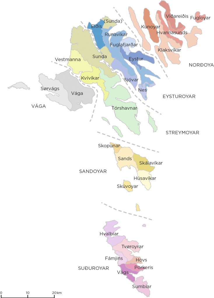
The municipalities in the southern part of Eysturoy are Nes Kommuna, Runavíkar Kommuna, Eysturkommuna, Fuglafjarðar Kommuna and Sjóar Kommuna. The southern part of Eysturoy is divided into four superior parishes.
The northern part
The two highest mountains in the Faroe Islands, Slættaratindur at 880 m and Gráfelli at 857 m can be found in the northern part of Eysturoy. This is also where the lake Eiðisvatn lies. The east side of the mountain ridge between Funningsfjørður in the east and Sundini in the west is characterised by deep valleys, also called cirque valleys. Where these meet each other, mountain passes or narrow mountain crests form.
Streymoy and Eysturoy were connected by a bridge over the sound at the village of Norðskáli in 1973. At that time, there was a road connection from Norðskála to Eiði, Gjógv and Funningur, roads that had been built from the late 1950s to the early 1960s. There was no road connection between Eysturoy’s western and eastern side, it only came with the Norðskála Tunnel in 1976 and the road between Funningsbotnur and Funningur 1987. Before the roads were built, the villages could only be reached by sea. The improved infrastructure has had a major impact on the development of the area.
In the past, there were several small municipalities in the northern part of Eysturoy. Gjógv had been an independent municipality since 1948 and merged with Sunda Kommuna in 2005. The former independent municipalities of Funnings Kommuna, Elduvíkar Kommuna and Oyndarfjarðar Kommuna merged with Runavíkar Kommuna between 2005 and 2009. Eiðis Kommuna has been an independent municipality since 1884. Since 1944, it has consisted of the outlying villages of Ljósá and Svínáir. Today, the northern part of Eysturoy is divided into three superior parishes.
In 2021, the northern part of Eysturoy consisted of the following municipalities: Eiðis Kommuna, Runavíkar Kommuna and Sunda Kommuna. Several villages on the northern Streymoy also belong to Sunda Kommuna.
Further reading
- Æðuvík (Settlement)
- Eiði (Settlement) and Eiðis Municipality
- Elduvík (Settlement)
- Fuglafjørður (Settlement) and Fuglafjarðar Municipality
- Funningsfjørður (Settlement)
- Funningur (Settlement)
- Gjógv (Settlement)
- Gøta (Settlements)
- Gøtugjógv (Settlement)
- Hellurnar (Settlement)
- Kambsdalur (Settlement)
- Lamba (Settlement)
- Lambareiði (Settlement)
- Leirvík (Settlement)
- Ljósá (Settlment)
- Nes (Settlement) and Nes Municipality (Eysturoy)
- Norðragøta (Settlement)
- Norðskáli (Settlement)
- Oyndarfjørður (Settlement)
- Oyrarbakki (Settlement)
- Oyri (Settlement)
- Rituvík (Settlement)
- Runavík (Settlement) og Runavíkar Municipality
- Saltnes (Settlement)
- Selatrað (Settlement)
- Sjóar Municipality
- Skálafjørður (Settlement)
- Skáli (Settlement)
- Skipanes (Settlement)
- Søldarfjørður (Settlement)
- Strendur (Settlement)
- Sunda Municipality
- Svínáir (Settlement)
- Syðrugøta (Settlement)
- Toftir (Settlement)
- Undir Gøtueiði (Settlement)
Read more about The islands, towns and settlements