In the log books from Skansin, the old fortress by the port in Tórshavn, you can find recorded weather observations dating as far back as 1782. However, it was not until 1866 that actual weather measurements began in the Faroe Islands on behalf of the Scottish Meteorological Society. Following its foundation in 1872 and until 2009, it was the Danish Meteorological Institute (DMI) which, in collaboration with local operators, was responsible for the measurements.
At the beginning, temperature, barometric pressure and rainfall were measured, but after World War II, when discarded equipment from the Royal Air Force became available, wind direction, wind speed and humidity have also been measured. Since then, the measurement programme has been extended to include cloud height, visibility and solar radiation. Balloon launch measurements (radio soundings) began just before the war and have continued to this day.
The current radiosonde and measuring station in Hoyvík started in 1993, and for a number of years it served as the headquarters for DMI’s activities in the Faroe Islands. The Løgting (the national parliament) took over the responsibility for the weather service in 2009 and since then, the Faroese fisheries inspection and rescue service Vørn has been in charge of the local measurement programme. In 2020, measuring stations were located in the lighthouses at Mykineshólmur, Borðan and Akraberg as well as in Kirkja, Eiði and Tórshavn.
In addition to a number of shortterm measurement projects carried out by various operators, the road administration, Landsverk, has since 1987 established a tight network of measuring stations, which are used to monitor both the conditions on the islands’ highways and the weather conditions, water levels and sea temperature in selected ports. Since 1979, Landsverk has, in collaboration with Vørn, also carried out regular wave measurements around the islands.
The weather in numbers
The climate in an area is often described by a climate normal, which is based on average weather measurements over a period of typically 30 years. For instance, the latest climate normal for Tórshavn is based on measurements from the period 1991‑2020. The measuring station in Tórshavn lies 55 m above sea level and has during the period recorded an annual mean temperature of 6.8°C, a total annual precipitation of 1,320 mm and an average number of sunshine hours of 869. In addition, there are 35 snow days on average per year.
However, the numbers for Tórshavn should only be considered as representative of the rest of the Faroe Islands to some degree, as the climate can differ considerably locally. Thus, Tórshavn often experiences fog in late summer, which results in a decrease in the number of sunshine hours at this time of the year. Rainfall also varies greatly, with the coastal areas typically getting approx. 1,000 mm per year, while rainfall in the central parts of the Faroe Islands can reach 4,000 mm per year. In addition, the temperature drops by approx. 0.65°C for every 100 m you move above sea level. This means that while the lowlying parts of the Faroe Islands have a temperate climate, high-lying areas have an arctic climate.
There is also great local variation in the wind, and, depending on the location of the measuring stations, they have measured annual mean wind speeds of between 4 and 10 m/s. The Faroe Islands are occasionally hit by very strong winds. During the infamous Christmas hurricane in 1988, an average wind speed of 59 m/s was measured at the high-lying Norðadalsskarð mountain pass over a period of ten minutes. In comparison, hurricanes have an average wind speed of at least 32.6 m/s.
Local weather
There are several explanations for the local climatic differences. The wind is affected by, e.g., the mountains, although their importance and impact are often so complex that it cannot be predicted by existing operational weather models. Somewhat simplistically, however, you can say that the mountains provide shelter from the wind when the wind speed is low to moderate. If, on the other hand, the wind speeds become extreme, the same mountains can lead to the formation of intense local turbulence. This can amplify the wind gusts to such an extent that they cause greater damage than if the wind had come from other directions.
Warm air can contain more water than cold air, and it is therefore the temperature that determines the dew point, i.e. the amount of water the air can contain before droplets start to form. Since the Faroe Islands lie between ocean currents, which are often warmer than the overlying air masses, the air over the islands is often close to the dew point. This explains why it is so often rainy and cloudy on the islands and why only small local changes are needed before clouds gather or fog forms in exposed places. For example, the mountains can be shrouded in fog within minutes, just as you can often escape the recurring summer fog in Tórshavn after just a 20-minute drive away from the area.
Like the wind, precipitation is also affected by the mountains. When the humid air moves over the islands, it is lifted up over the mountains and cooled. This results in increased precipitation in the mountains, but also means that the air dries out a little. On the downwind side of the mountains, the weather conditions will therefore often be better; at best with clear weather and higher temperatures. A popular local rule of thumb also says that if you want better weather, you must move as far as possible in the direction of the wind.
Conditions at sea
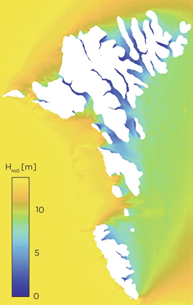
The Faroe Islands lie more or less in the middle of the path of the migrating North Atlantic low pressure. This leads to strong wave activity, and the local wave climate is among the most challenging in the world. In general, the west side of the islands is most exposed to wave activity, while the east side is more sheltered.
The difference between high and low tide is quite modest. Due to the layout of the islands, however, narrowings occur, which over short distances can cause such massive tidal differences that the tidal currents in certain places become so strong that they become a challenge to vessels with moderate engine power. Particularly dangerous situations can occur where strong tidal currents move against the direction of the waves. The waves can then develop into breaking waves, which roll over the ships and, at worst, can capsize mainly small vessels.
Further reading
- Climate on the Faroe Islands
- Geology on the Faroe Islands
- Landscapes and coasts on the Faroe Islands
- The sea around the Faroe Islands
Read more about Nature and landscape on the Faroe Islands