ÓLAVUR FREDERIKSEN/TRAP FAROE ISLANDS, 2021
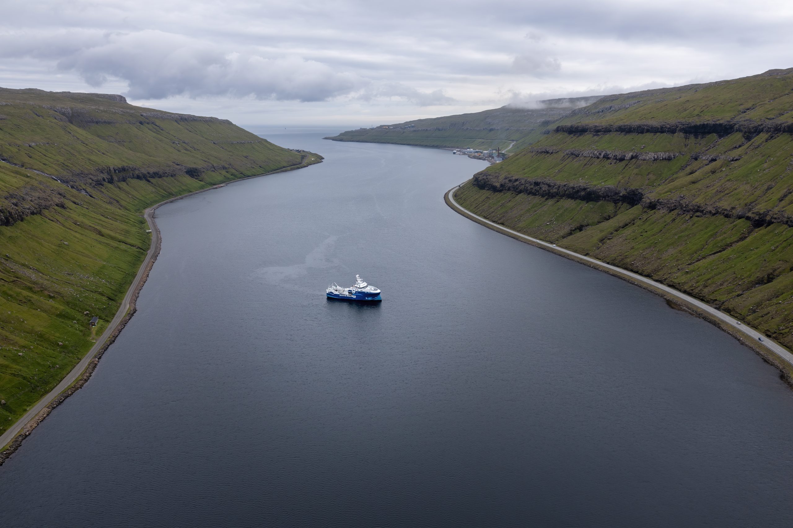
Nowhere in the Faroe Islands is the coast more than 5 km away, and the significance of the surrounding ocean to the climate, nature and business sector is enormous. As much as 99.5 % of the Faroese area is sea, which corresponds to almost three times the Danish sea area. The large sea area stretches from the warm Atlantic Ocean in the southwest to the cold Norwegian Sea in the north and comprises deeply incised fjords along the coast and open ocean with depths that can reach several thousand meters.
To the north, the Faroese sea area borders on the Icelandic and Norwegian sea area, while it adjoins British waters to the south. In 2021, the delimitation of the sea area to the southwest had not yet been clarified and was awaiting a decision in the UN.
Bottom topography
The Faroe Islands are located on the Greenland-Scotland Ridge, which is a submarine ridge that stretches from Greenland to Scotland. The ridge separates the North Atlantic from the Nordic seas to the north and plays a crucial role in the circulation of the water masses in the area. The part of the ridge that is located between Iceland and the Faroe Islands is called the Iceland-Faroe Ridge. In this section, large parts of the ridge are shallower than 500 m, although the ridge gradually deepens towards the Faroe Islands until it reaches the plateau on which the islands are located.
The plateau itself is often defined as an area where the bottom depth does not exceed 200 m. The southern tip of the plateau is relatively long and narrow and partly marks the transition between the Faroe-Shetland Channel to the southeast and the Faroe Bank Channel to the southwest. West of the plateau are three large banks, of which the Faroe Bank is both the largest and the one closest to the Faroe Islands, followed by Bill Baileys Bank and Lousy Bank. From Faroe Bank, the submarine ridge continues as the Wyville Thomson Ridge onto the Scottish plateau.
Apart from the part facing the Iceland-Faroe Ridge, the entire Faroese plateau is surrounded by deep water. In the Faroe-Shetland Channel, bottom depths reach more than 1,000 m, while the Faroe Bank Channel, with a sill depth of 840 m, is the deepest passage across the Greenland-Scotland Ridge.
The open ocean areas
The open ocean around the Faroe Islands is characterised by the large water masses that come from the southwest as warm Atlantic water and from the northeast as cold Arctic water, respectively. The flows of the two water masses are part of the thermohaline circulation, which plays a significant role in the Faroese climate, just as they are decisive for the currents, the temperature and the salinity of the surface and deep water in the open ocean.
The density of water depends on both temperature and salinity, which means that warm water with low salinity is light, while cold water with high salinity is heavy. The warm Atlantic water moved north by the North Atlantic Current towards the Faroe Islands is therefore surface water. The current bifurcates and crosses the Iceland-Faroe Ridge and then merges into the Faroe Current north of the Faroe Islands. After this, the current bifurcates again, with one branch continuing east towards Norway, while the other turns southwest into the Faroe-Shetland Channel. The branch that flows into the Faroe-Shetland Channel meets a branch of Atlantic water from the west and southwest. They join and follow each other northeast past the Shetland Islands. The many currents are all branches of the North Atlantic Current, and together they account for the surface water in almost all Faroese waters being warm Atlantic water.
As the Atlantic water moves further and further north, it cools and becomes cold arctic water. At the same time, it mixes with fresh water and less salty seawater, which means that part of the Arctic water remains so light that it is able to stay in the upper water layers. The Arctic surface water moves south, but is blocked north of the Faroe Islands by warm Atlantic water.
However, most of the Arctic water retains most of its salinity and, as it also cools rapidly, it sinks to great depths. The large basins north of the Greenland-Scotland Ridge are therefore filled with cold arctic water. Via the deep channels, the arctic deep water crosses the submarine ridge and flows to the southwest. Although the largest flow occurs via the Denmark Strait between Greenland and Iceland, around a third of the water flows through the Faroe-Shetland Channel and on through the Faroe Bank Channel. A smaller part also manages to flow over the Iceland-Faroe Ridge and the Wyville Thomson Ridge, respectively.
When the Arctic deep water leaves the channel, it joins Atlantic water at a depth of 500‑1,000 m. At such great depths, the Atlantic water is cooler than at the surface, but it is still significantly warmer than the cold Arctic deep water, and the mixing of the two water masses is intense. A corresponding mixing occurs with the Arctic deep water from the Denmark Strait, and together these mixed water masses are called North Atlantic Deep Water. The North Atlantic Deep Water covers large parts of the deep Atlantic where it transports mainly oxygen (O2) but also carbon dioxide (CO2) from the North Atlantic to the southern part of the Atlantic and from here on to the Pacific and the Indian Ocean.
The plateau area
The Faroese plateau covers an area of about 20,000 km2 and has an average depth of 100 m. To the north, the plateau is relatively flat, but there are also several banks, which are bounded by deeper channels, especially to the east. Currents on the plateau are characterised by strong tides, which in places can reach speeds of more than 1 m/s. The tidal waves from the Atlantic and the Norwegian Sea meet here and form a so-called amphidromic point around which they move. At the amphidromic point, there is virtually no tidal amplitude. The movements of the tidal waves and the location of the amphidromic point mean that the difference between high and low tide is greatest to the west and becomes smaller and smaller to the east, while gradually delaying the times of ebb and flood at the same time. At Tórshavn, for example, the tidal amplitude is very small. The delay and the variation in the size of the tide create very strong tidal currents between the islands, just as they contribute to the water on the plateau circulating clockwise.
The strong tidal currents mix the water above the plateau (shelf water), and in the shallow parts the water is mixed from bottom to top all year round. In winter, the shallow areas cool more than the surrounding waters, so that at a depth of around 100 m, a front forms between the cool shelf water and the warm Atlantic water. The front is very dynamic, and in May-June it becomes more layered and takes the form of a typical tidal front. In spring, the entire front formation is largely controlled by the atmospheric conditions and it may therefore vary greatly from one year to the next. If the conditions are favourable, large algal blooms can occur in the mixed shelf water early in the year and later also in the front area. In some years, however, the optimum conditions are not present and algal blooms are modest.
The temperature of the shelf water changes with the seasons. The lowest temperatures are typically 6‑7°C from the end of February to March, while the highest temperatures are seen in August and September at 10‑11°C. The temperature is partly determined by the atmosphere, but also by warm and cold periods in the Atlantic water. At the end of the 1910s as well as in the mid-1990s, the Atlantic water was relatively cold, while for the past 15 years it has been in a fairly stable warm period.
The fjords
The Faroe Islands have a very long coast with long, incised fjords, which are connected to the ocean through narrow mouths. Several of the fjords are sill fjords, where one or more sills divide the individual fjord into deeper basins, and where the shallowest sill is typically at the mouth. At the bottom of the fjord and along the sides, there is an inflow of fresh water from rivers.
Since the tidal impact on the fjords is usually low, the fresh water from the rivers immediately mixes with the seawater and becomes brackish. Due to its lower salinity, the brackish water is lighter than seawater and settles as a 10‑20 m layer at the surface. The brackish water flows towards the fjord mouth, and to compensate for the outflowing, brackish surface water, salty shelf water flows into the fjord under the brackish water.
In summer, the shelf water warms and can therefore become so light that it does not sink to the bottom of the fjords. In the deeper basins of the sill fjords, this can mean that the bottom water is not replaced, causing oxygen depletion. It occurs every year in Skálafjørður, which is the longest and deepest fjord in the Faroe Islands. The period of oxygen depletion can last several months, but ends when temperatures drop in autumn and cool shelf water starts bringing oxygen to the bottom water again.
Faroe Bank Channel
West of the Faroe Islands, between the Faroe Bank and the Faroese plateau, is the Faroe Bank Channel, which together with the Denmark Strait is responsible for the vast majority of the cold deep water transported from the Norwegian Sea and on into the world’s oceans. Both cut across the Greenland-Scotland Ridge, and with a sill depth of 840 m, the Faroe Bank Channel is the deepest of the two.
However, the Faroe Bank Channel is narrow, and in the deep part at the sill, it is only 10 km wide. The cold Arctic deep water, which flows through the deepest 200‑300 m of the channel, therefore reaches a speed of approx. 1 m/s. This means that the volumes of water that pass through the Faroe Bank Channel are enormous. Every second, an average of about 2,000,000–m3 of Arctic deep water flow through the channel, corresponding to about twice the total water transport of all the world’s rivers.
Coastal Macroalgae
Algae is a collective term for several different groups of organisms and comprises representatives from both plants, protists and bacteria. They are often divided into microalgae and macroalgae, where the macroalgae are the larger, multicellular species. Most macroalgae are marine, sessile organisms that grow along the coast in areas where the substrate is stable. Together with the sea grasses, they are also called seaweed. The Faroese rocky coasts have an abundance of macroalgae, and the extensive, lush seaweed forests play an important role in the coastal marine environment, just as they are habitat and breeding ground for a number of fish species and an even greater number of invertebrates.
Growth conditions
Light, concentration of nutrient salts, salinity and temperature are all decisive for the growth and spread of macroalgae. While the salinity in the sea around the Faroe Islands remains fairly stable at around 35‰ all year round, light, sea temperature and the amount of dissolved nutrient salts vary with the seasons. The light intensity determines how deep the macroalgae can grow, just as it determines the growth rate. The same applies to the sea temperature, which fluctuates from around 7°C in winter to 10‑11°C in summer. Since the temperature, day length and light intensity peak in the summer, it is also during this period that macroalgae grow the most.
The concentration of dissolved nutrient salts is also a limiting factor for algae growth and like light and temperature, it is seasonal. Nitrate (NO3-) is usually the nutrient salt that is depleted the fastest and thereby becomes a limiting factor for macroalgae growth. Measurements in the water above the Faroese plateau have shown that the nitrate concentration fluctuates from 2.2 to 10.2 μM in May-September. The fluctuations are linked to the growth of microalgae in spring and summer. Due to their size, the planktonic microalgae are far more efficient at absorbing the dissolved nutrient salts than the macroalgae, and both nitrate and other nutrient salts are therefore quickly bound in the microalgae biomass. In the upper water layers of the fjords, where the density of microalgae is highest, the nitrate can be completely depleted, causing that the concentration to drop to about 0 μM for shorter or longer periods. However, waves and currents also affect nitrate concentration, and measurements in Kaldbaksfjørður have shown that the periods of very low concentration are shortest in the areas where the fjord is most exposed.
The zoning of algae populations
Each of the many species of macroalgae makes specific demands on the environment in which they grow, and they are therefore distributed in different habitats, each characterised by certain environmental factors such as degree of drying, temperature, light intensity, currents, etc. The macroalgae can be found somewhere above the intertidal zone to a depth of more than 30 m where they are distributed according to depth and exposure, creating a more or less clear zoning.
When the waves crash over the most exposed coasts, the seawater sprays high up against the rocks, which means that certain macroalgae are able to grow up to 20 m above the intertidal zone. In the fjords and on the more sheltered coasts, on the other hand, the boundary for the upper distribution of the algae is to a greater extent determined by the tide. Here, the intertidal zone is characterised by brown algae such as rockweed (Ascophyllum nodosum) and bladder wrack (Fucus vesiculosus), both of which form floating bladders, which give them buoyancy. Rockweed in particular is an indicator of sheltered coasts and is completely absent where the coast is exposed. Bladder wrack tolerates a higher degree of exposure, although it only appears sporadically on exposed coasts and typically grows in rock crevices where it is protected from the surf. On the exposed coasts, intertidal zones are instead characterised by various red algae such as coral weed (Corallina officinalis), false Irish moss (Mastocarpus stellatus), dulse (Palmaria palmata) and purple laver (Porphyra umbilicalis) as well as the brown algae thongweed (Himanthalia elongata). Around the low water line, you can also find the brown algae winged kelp (Alaria esculenta).
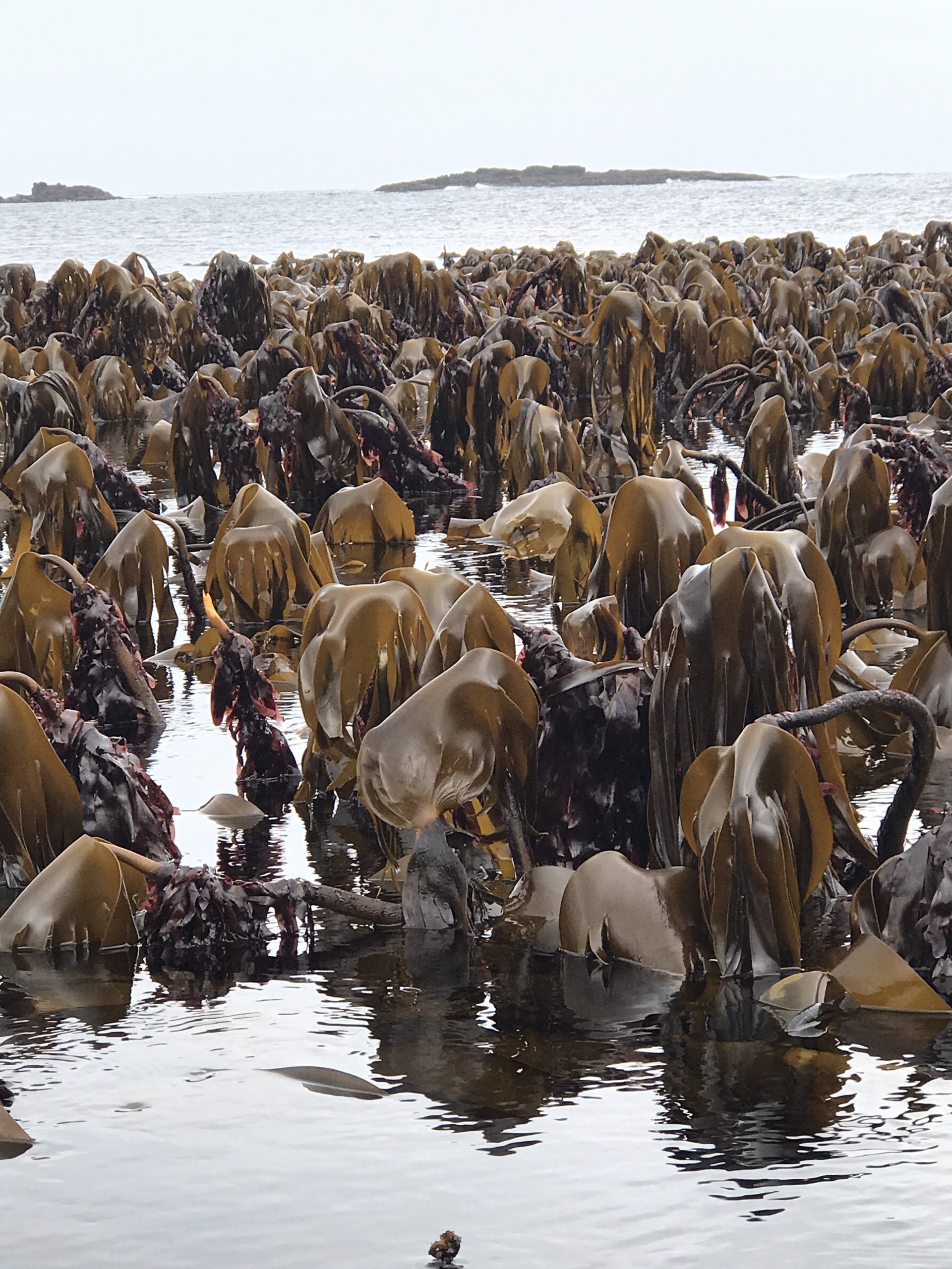
Below the low water line, in the perpetually water-covered zone, species that do not tolerate drying start to appear. Conditions are especially good for macroalgae on the exposed coasts. Here, the current and the waves have removed the sediments, leaving stable substrates onto which the macroalgae can attach. The large species of kelp now start to appear; first oarweed (Laminaria digitata) and, slightly deeper, cuvie (Laminaria hyperborea), which in this zone form large, extensive kelp forests. At a depth of 20 m, the kelp forests on the exposed coasts begin to thin out. When you reach a depth of 30 m, cuvie only appears in small numbers and at these depths the dwindling light is probably a limiting factor for the spread of algae.
On the sheltered coasts, the macroalgae are only found at a depth of a few metres. The limiting factor is often the substrate, which, due to the modest water movement, forms a thick layer of very fine mud, to which algae cannot attach. Large brown algae such as sugar kelp (Saccharina latissima), oarweed and cuvie dominate the upper meters and are distributed in the stated order. Contrary to the exposed coasts, cuvie does not manage to form large kelp forests, and the individual kelp plants are generally small.
A diversity of macroalgae
As part of the comprehensive Biofar project, the diversity of macroalgae in the Faroe Islands was thoroughly studied over a period from July 1994 to August 2000. Phycologists Ruth Nielsen and Karl Gunnarsson beaded the study, where macroalgae were collected from 265 locations spread across the islands. The study was able to document a total of 260 different species of macroalgae distributed into 113 species of red algae, 83 species of brown algae and 64 species of green algae. Of these, 41 species were not previously known from the Faroe Islands.
In connection with the study, focus was mainly aimed at coralline red algae and laver. Subsequently, work on particularly laver was continued, leading to the discovery of an entirely new species, which was officially described in 2012. The species was named Pyropia njordii after Njord (Njørður), who in Norse mythology was the god of, among other things, the sea. In addition to the Faroe Islands, the species is also known from Iceland, Greenland, New England in the USA and Nova Scotia in Canada, but the type specimen, which defines the new species, was collected in 2006 at Tjaldavík in Trongisvágsfjørður on Suðuroy.
The work carried out in connection with the Biofar project makes it possible to record changes in the Faroe Islands’ macroalgae population. So far, no changes have been recorded, but it is expected that due to rising sea temperatures caused by global climate change, new species of macroalgae will eventually immigrate from the south.
Cultivation of macroalgae
AGNES MOLS MORTENSEN, 2020
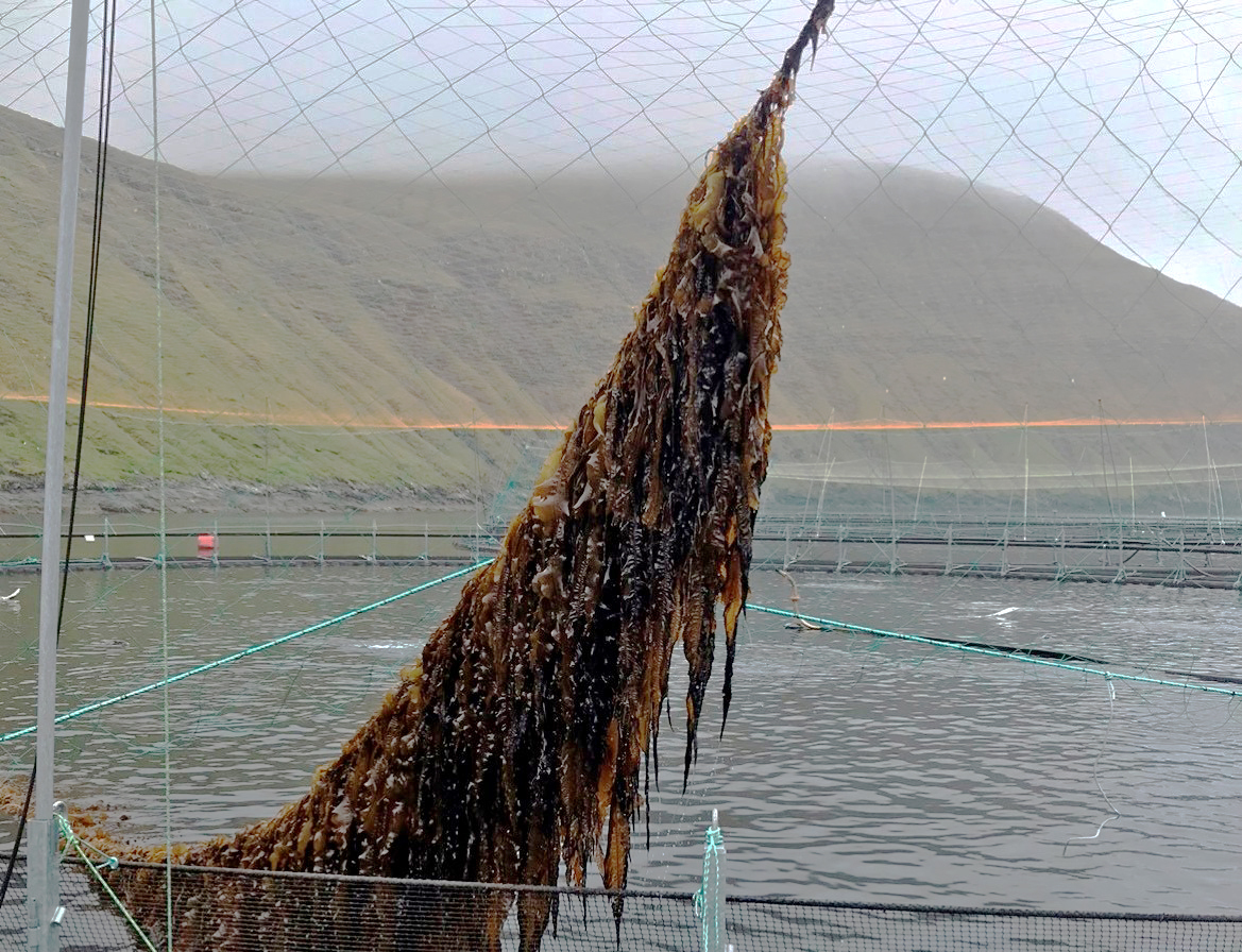
Although Asia has a long tradition of cultivating and eating macroalgae, macroalgae cultivation in Northern Europe is in its infancy. However, the Faroe Islands have already had several years of experience with the cultivation of winged kelp (Alaria esculenta) and sugar kelp (Saccharina latissima), and actual commercial exploitation is gradually being established around the two species. Cultivation trials have also been carried out with cuvie (Laminaria hyperborea), oarweed (Laminaria digitata) and dulse (Palmaria palmata), but none of these are yet cultivated on a commercial scale.
In 2005, the Nordic initiative Nordic Seaweed Project was behind the first cultivation trials in the Faroe Islands. Attempts were first made at cultivating winged kelp, which proved to have great potential. Subsequently, Fiskaaling (Aquaculture Research Station) has started research in macroalgae and considers the cultivation of macroalgae as a new aquaculture in the Faroe Islands.
Today, two companies have been established in the Faroe Islands with macroalgae cultivation as their main activity: TARI – Faroe Seaweed and Ocean Rainforest. The first three licences for macroalgae cultivation were issued by the Faroese authorities in July 2020. Thus, Ocean Rainforest was given licence to cultivate sugar kelp in Funningsfjørður, while TARI – Faroe Seaweed was given licence to cultivate winged kelp, oarweed, sugar kelp, dulse and umbilical purple laver in Kaldbaksfjørður. In addition, TARI – Faroe Seaweed was given permission to establish a landbased facility in Fámjin. Here, the propagation materials used in the further cultivation process are isolated, and the ropes on which the macroalgae grow are seeded.
The macroalgae produced in the Faroe Islands are sold both for human consumption and as finished and ingredient products. Some are also sold as animal feed. Among the many products are, for example, Ocean Wings, which is based on locally grown winged kelp.
Cuvie – the largest macroalgae in the Faroe Islands
With a total length of almost 3 m, curvie (Laminaria hyperborea) is the largest macroalgae in the sea around the Faroe Islands, where it is the supporting, structural element in the large, coastal kelp forests. Cuvie belongs to the brown algae and, together with sugar kelp and oarweed, is called kelp.
Like the other species of kelp, cuvie has a strong holdfast (haptera), a long and strong stem with a rough surface and a thick and leathery leaf plate, which is divided into numerous fingerlike sections. Both the holdfast and the stem are perennial, while the leaf plate withers and must be formed anew every year. In the late winter months, you can thus see the new leaf growing from the transition between the stem and the old leaf. The stem itself can be up to 2.3 m long, and as with trees, it is possible to determine the age of an individual of cuvie by making a cut at the bottom through the stem and counting the growth rings. The oldest cuvie found in the Faroe Islands was 13 years old.
A rich wildlife and algal life is attached to the cuvie’s stem and holdfast. At low tide, for example, you can clearly see the red algae dulse (Palmaria palmata) growing on the upper part of the cuvie stem. Dulse is a common red algae in the Faroe Islands where it grows from the intertidal zone out to approx. 15 m depth. It is also a popular edible algae.
Macroalgae in salmon farming
AGNES MOLS MORTENSEN, 2019
Salmon louse (Lepeophtheirus salmonis) constitutes a major challenge in salmon farming in the Faroe Islands. The small crustacean lives as a parasite on the salmon where it feeds on the fish’s mucus, skin and blood.
For years, salmon farmers have used lumpsuckers (Cyclopterus lumpus) to get rid of the salmon lice. The lumpsuckers are released into the farms together with the salmon, where they serve as effective lice eaters. Unfortunately, the lumpsuckers do not thrive in the farms. However, among the many attempts to improve the conditions for the important ‘cleaning fish’, macroalgae have proved to be a possible solution. Unlike the free-swimming salmon, lumpsuckers need a substrate to sit on and hide in, and since they are found naturally in seaweed forests, many salmon farms have tried introducing plastic shelters that are meant to imitate kelp.
As an alternative to the plastic shelters, TARI – Faroe Seaweed, together with the salmon industry, has developed a more natural seaweed shelter for the lumpsuckers. Various macroalgae are grown on the seaweed shelters, so that they function as a kind of floating kelp forests, where the lumpsuckers can hide. The idea is that the natural seaweed shelter become a sustainable way of creating better living conditions for the lumpsuckers.
Further reading
- Benthic animals
- Fish
- Fresh Waters on the Faroe Islands
- Geology on the Faroe Islands
- Landscapes and coasts on the Faroe Islands
- Nature and environmental management
- Seals
- Whales
- Wildlife on the Faroe Islands
Read more about Nature and landscape on the Faroe Islands