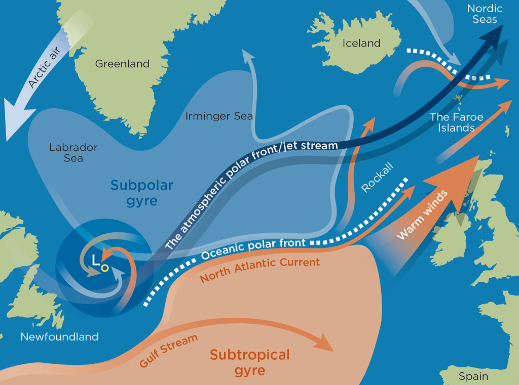
Its location in the North Atlantic, surrounded on all sides by strong ocean currents, means that the Faroe Islands have a distinctive coastal climate. A major climate factor is the North Atlantic Current, which is a northeastern branch of the warm and salty Gulf Stream, which runs north along the east coast of North America. At Newfoundland, the Gulf Stream meets the cold Labrador Current, which pushes it away from land. From here, it continues to the northeast as the North Atlantic Current through the North Atlantic to the waters around the Shetland Islands and the Faroe Islands.
The North Atlantic Current is of great importance for the oceanographic and climatic conditions and thus also for the natural resources in and around the islands. On its 6,700-km long journey, it loses much of its heat surplus due to the heat exchange of the surface water with the atmosphere at the same time as cold subarctic water reaches the deeper parts of the current’s left flank. Despite the heat loss, the North Atlantic Current is still so warm that it gives the Faroe Islands a relatively mild climate all year round.
However, the climate is not controlled by the North Atlantic Current alone. The warm ocean current is part of a complex interaction with other ocean currents, which, together with the low pressure systems that form at the atmospheric polar front, play an important role in the climatic conditions on the islands.
Three driving mechanisms on a large scale
Seen in a larger context, the climate in and around the Faroe Islands is controlled by three driving mechanisms: the thermohaline circulation, the oceanic polar front and the atmospheric polar front.
The thermohaline circulation
The Gulf Stream and the North Atlantic Current form part of a global cycle of coherent ocean currents that exchange heat between the tropics and the poles. The transport of the large water masses is partly driven by changes in the density of the water, which are caused by differences in temperature and salinity. As the warm Atlantic surface water moves north, it loses heat to the atmosphere. The falling temperature increases the density of the water so that it sinks and drifts south, pulling warmer surface water north. This phenomenon is called the thermohaline circulation and is the main reason why the waters around the Faroe Islands are warmer than anywhere else at the same latitude in both the northern and southern hemispheres. The other reason is the large atmospheric heat transport carried by the westerlies under the atmospheric jet stream. The Faroese area is therefore also popularly referred to as a large ‘climate oasis’.
Research suggests that the thermohaline circulation was significantly weakened during the ice ages, and it is believed that this weakening contributed to the formation of the cold periods in the north. In connection with climate change, where rising temperatures lead to less cooling, concern has been voiced about whether a corresponding weakening of the thermohaline circulation can be expected in the future. Over the past 25 years, regular measurements have been made of the inflow of Atlantic water to the Faroe Islands, but they have yet to demonstrate any weakening.
The oceanic polar front
In addition to being part of the thermohaline circulation, the Gulf Stream is also part of the subtropical gyre, which is a large, warm, rotating ocean current or eddy that, driven by wind and the Coriolis force, slowly rotates clockwise. To the north, the subtropical gyre adjoins the southern boundary of the subpolar gyre, which is a cold eddy that rotates counterclockwise. On the dividing line between the two oppositely rotating ocean currents runs the oceanic polar front, which controls the direction of the North Atlantic Current.
Although the Gulf Stream moves at a fairly uniform speed, it moves quite a bit in a northern and southern direction, especially in the area where it moves away from the American continental shelf. This affects the course of the oceanic polar front along the western side of the North Atlantic. Where the North Atlantic Current approaches the Faroe Islands, a varying but relatively large part of the current breaks off and continues in between the Rockall rock and the Hebrides. This current affects the course of the oceanic polar front along the eastern side of the North Atlantic.
Both the prevailing wind and the size and strength of the subpolar gyre are closely linked to the oceanic polar front in the west and the east. During periods when the subpolar gyre is large and powerful, vast volumes of cold arctic water will be led between Rockall and the Hebrides. This makes the sea around the Faroe Islands colder, which, in turn, causes the air temperature on land to drop.
At a submarine ridge between Scotland and Iceland, the warm, salty Atlantic water meets the cold and less salty water masses from the north. This is mainly the East Iceland Current, which is a branch of the large south-going and ice-filled East Greenland Current. To emphasise the importance of the warm Atlantic ocean currents, try imagining that the part of the North Atlantic Current that moves north of the Faroe Islands (the Faroe Current) disappeared. The cold East Iceland Current would then surround the plateau on which the Faroe Islands lie, and the climate would become arctic.
A diverging wind field in the area south of Greenland and Iceland causes the surface water of the sea to spread in a fan shape. To replace the water that is pushed out to the sides, cold water rises from the deep parts of the subpolar gyre. In winter, the surface water in the Labrador Sea and the Irminger Sea undergoes significant cooling due to cold, dry winds blowing from the North American continent. Since cold water is heavier than warm water, the cooled surface water will sink at the same time as it pushes a corresponding volume of water up from the depths. Both processes cause nutrient-rich bottom water to flow up towards the surface; a phenomenon called ‘upwelling’.
The upwelling bottom water means that the sea around the Faroe Islands is very nutrient-rich and therefore rich in plankton, which is the foundation of a large food web. The plankton serves as nutrition for large amounts of crustaceans and other zooplankton, which are eaten by small fish, which in turn are preyed on by larger fish, seabirds and marine mammals such as seals and whales.
The atmospheric polar front
While the oceanic polar front follows the boundary between cold and warm water, the atmospheric polar front, or simply the polar front, moves in the boundary region where the cold polar air from the north meets warmer air from the south. It is in this zone that the migrating Atlantic low pressure systems which impact the weather are formed.
The low pressure systems typically develop in the zone between the warm, humid air, especially over the Gulf Stream and the often counterflowing, cooler, heavier and drier sea air. On either side of the polar front, small differences in the wind fields cause the front to meander, forming a front system. The opposite wind directions will, in one direction, pump warm, humid air up above the cold air, so that a warm front develops and, in the opposite direction, push cold polar air under the warm and lighter air to form a cold front. A warm sector is developed between the warm front and the cold front. In the area where the warm fronts and the cold fronts meet, low pressure systems develop rapidly and migrate mainly to the east and northeast with the overlying jet stream. The jet stream over the North Atlantic is a high-altitude system of mainly easterly winds, which at a height of approx. 10 km and at speeds of up to 500 km/h winds its way between the tropospheric and stratospheric layers.
The weather in the Faroe Islands largely depends on the passage of low pressure systems past or over the islands, and since the jet stream varies somewhat in both strength and the path it follows, the behaviour and routes of the low pressure systems over the North Atlantic change from year to year. If the low pressure systems pass north of the Faroe Islands, the islands will first be hit by a warm front, which can result in an extended period of rain. This is followed by a cold front with increased wind force and heavier showers, which may occasionally include hail and thunder. In the period between the warm front and the cold front, there will typically be light rain or fog, although the warm sector can also bring spells of good weather with partial clearing skies. If, on the other hand, the low pressure systems pass south of the Faroe Islands, they draw cool air down over the islands. They often also produce strong winds and large amounts of precipitation which can last up to a whole day for just a single low pressure system passage. However, the low pressure systems often also move so centrally across the islands that these typical features and effects are mixed together.
If the jet stream forms a U-shaped arc just west of the Faroe Islands, the low pressure systems intensify and are carried across the islands from the north. This sends very steep and energetic fronts over land, which can result in the very violent winter storms that have several times caused considerable destruction in and around the Faroe Islands.
Further reading
- Geology on the Faroe Islands
- Landscapes and coasts on the Faroe Islands
- Nature and environmental management
- Plant life on land on the Faroe Islands
- The sea around the Faroe Islands
- Weather conditions on the Faroe Islands
Read more about Nature and landscape on the Faroe Islands