ÓLAVUR FREDERIKSEN/TRAP FAROE ISLANDS, 2021
The Mid-Atlantic Ridge on the floor of the Atlantic Ocean stretches from the Greenland Sea in the north and all the way to the waters of Antarctica in the south. The ridge is a socalled mid-ocean ridge, which marks where the tectonic plates move away from each other. Although the ridge is largely submarine, it briefly makes landfall in Iceland where it divides the country in two: a western part, which lies on the North American tectonic plate, and an eastern part, which lies on the Eurasian tectonic plate.
The formation of the Mid-Atlantic Ridge began approx. 175 million years ago, but its extension to the north did not occur until much later. This period is associated with the opening of the North Atlantic and is one of the most violent volcanic episodes in Earth’s history. And, at the same time, it tells the story of how the Faroe Islands came about.
Some 62 million years ago, the tectonic plates in the North Atlantic began to move away from each other, resulting in violent volcanic activity. The gigantic volcanic eruptions spewed out large amounts of basaltic lava, which during the following 6 million years created a huge land area in the form of The North Atlantic Igneous Province. Today, this land area can be found in Baffin Bay in Canada, on Disko Island in West Greenland and down the entire East Greenland coast as well as along the eastern part of the North Atlantic from Northern Ireland and Scotland and on to the Faroe Islands.
The lengthy volcanic activity and thus also the formation of the Faroe Islands are linked to the continental drift that began with the breakup of the supercontinent Pangea, which separated Europe and Africa from North and South America. The volcanism, which gradually reached the North Atlantic some 62 million years ago, intensified around 58 million years ago in the area between Greenland and Northwest Europe. The reason was that large amounts of magma from a particularly hot part of the asthenosphere began to move upwards to form the so-called Icelandic mantle plume, which some 17 million years ago raised Iceland above the seabed. This led to extremely violent volcanic activity with associated lava production, the likes of which has not been seen on Earth since. The Faroe Islands and the submarine plateau on which the islands lie are the very remnants of these volcanic events.
Faroese geology
DIRK WIERSMA/SCIENCE PHOTO LIBRARY/RITZAU SCANPIX, NO YEAR
The Faroese area covers an area of 293,623 km2, of which 99.5 % is sea and just under 0.5 % is land. The area’s land and seabed surfaces are extremely varied with a geology that reflects the tectonics and erosion of a volcanic area over more than 50 million years.
In the first half of the 1990s, hydrocarbon exploration began in the Faroese area. Nine wells have been drilled so far, and although hydrocarbons have been found in some of them, the volumes found have not justified commercial exploitation. On the other hand, the seismic surveys and other methods used in the exploration have greatly contributed to the understanding of the area’s geology.
Deep seismic surveys of the continental shelf under the Faroe Islands and the surrounding regions show that the earth’s crust has repeatedly been stretched considerably in connection with the breaking up of the continent since the Devonian about 385 million years ago. Furthermore, geochemical analyses of the Faroese basaltic layers suggest that the continental crust under the Faroe Islands is from the Precambrian. This means that it is more than 541 million years old and thus of the same age as the East Greenland and Scotland bedrock. The Faroe Islands lie on the edge of the continental crust, which stretches from the western part of the Barents Sea in the north to the sea area west of Ireland in the south. The continental crust is characterised by a series of sedimentary basins that were created during periods when the crust was stretched, as happened, for example, during the breakup of the supercontinent Pangea. It is the boundary between the two oceanic crusts that is volcanically active today (e.g. in Iceland).
Geology on land – the formation of the flood basalts
ÓLAVUR FREDERIKSEN, 2020
The geology of the Faroe Islands is relatively simple with alternating layers of basalt and volcanic clay and sandstone, which consist of basaltic weathered material, clay slate and tuff. Although the layer sequence is simple, it tells quite a dramatic geological story. The dark basaltic layers testify to violent volcanic eruptions, where basaltic lava layer by layer created the landscape that makes up the Faroe Islands today. The thin intravolcanic layers were deposited in the periods between the volcanic eruptions and contain, for example, plant fossils appearing as impressions and thin carbon films between the often reddish layers of clay and sandstone. The fossils show a subtropical flora and reveal that a lush rainforest grew in the area at this time.
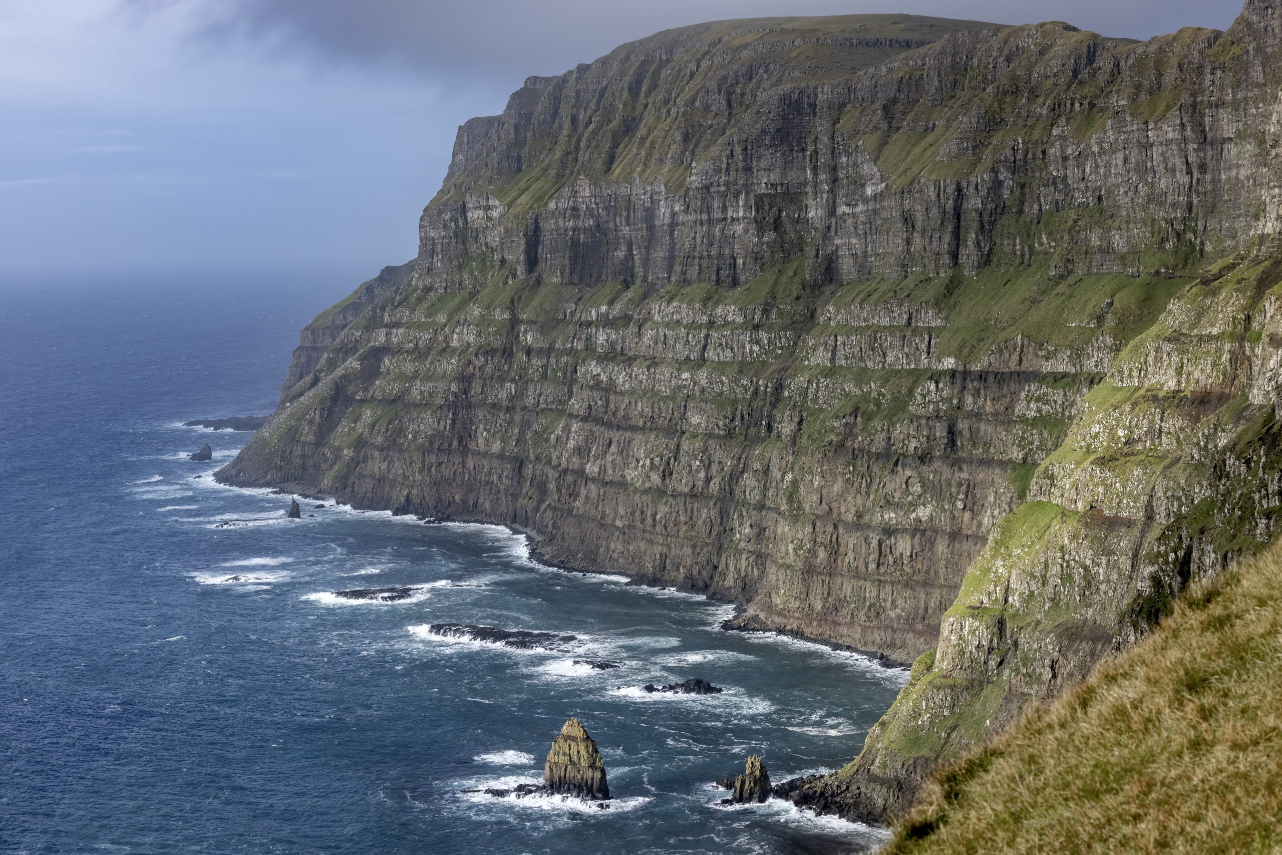
Along Suðuroy’s west coast and north to the northern islands, you can often follow individual basaltic horizons from one island to the next. The layer sequence shows the formation of the original basalt plain, which was created layer by layer in step with the alternating volcanic eruptions and intermediate calm periods. Differences in the types of eruptions and magnitude are revealed by two dominant types of lavas: one type, which is made up of relatively uniform, approx. 20 m thick lava flows (‘simple aa flows’), and a type which is made up of many, often quite thin lava flows (‘compound pahoehoe lava flows’).
The volcanic eruptions which created the lower and oldest part of the Faroe Islands are from the time before the opening of the North Atlantic. These volcanoes were probably fissures, which lay in northwest-southeast direction west of the present location of the Faroe Islands. The fissures have produced enormous amounts of lava with a regularity and to an extent seen only in the formation of basalt plains.
The beginning of volcanism – the Lopra Formation
The 3,565 km deep Lopra borehole on Suðuroy resulted in the description of the oldest known part of the Faroese basalt sequence, which, based on radiometric dating, was estimated to have an age of 60.8 million years. The borehole was carried out in two rounds in 1981 and 1996, respectively, and aimed to obtain lithological and stratigraphic data about the deepest parts of the Faroese basalt sequence and the underlying geological formations. The background for the drilling was predominantly an interest in investigating the possibilities for oil exploration in the area.
The borehole never made it down through the volcanic sequence, and the final thickness of the volcanic layers could therefore not be determined. However, the investigations showed that the Lopra Formation is more than 1,000 m thick and that the rocks alternate between volcanic sandstone and hyaloclastites, which are rocks formed when lava meets water. In the deep part of the Lopra Formation, there are also a number of intrusive rock types.
Pulsating lava formation – the Beinisvørð Formation
The mightiest of the formations in the Faroe Islands is the Beinisvørð Formation, named after a 469 m high cliff on southwestern Suðuroy. The formation was created by a rhythmic production of magma, which was linked to the fissures west of the Faroe Islands. The resulting basalt sequence has a total thickness of approx. 3,250 m, of which approx. 890 m is exposed, while the rest is located underground and was documented in the Lopra borehole. The formation is made up of extremely thick basaltic lava flows, where each flow reflects a period of volcanic activity. The individual basalt lava flows are on average 20 m thick, but reaches a thickness of more than 70 m at Fámjin. Each basaltic lava flow is composed of a bottom crust, a more solid and massive basaltic core and an upper crust that is often fractured and filled with vesicular pores.
Columnar basalts are common in this formation and consist of pentagonal or hexagonal columns that formed as the lava slowly cooled and contracted. Basaltic lava flows with column formation can, for instance, be seen in Froðba on Suðuroy as well as in Korkadalur on the north side of the island of Mykines where the basaltic columns reach heights of up to 30 m. Between the individual basaltic lava flows are reddish sedimentary layers, which become thicker and more carbon rich in the upper part of the formation. This suggests that the periods between individual volcanic eruptions have gradually become longer and longer.
Today, the Faroese area lies east of the Mid-Atlantic Ridge and thus also east of the mid-ocean ridge zone. This means that the original formation was divided between east and west, and you have to go to the Blosseville area on the east coast of Greenland if you want to experience the remains of the basaltic lava flow that ended up west of the mid-ocean ridge zone. Here they make up the Nansen Fjord Formation, whose exposed parts are to some extent reminiscent of the Faroese landscape.
Lush forests and freshwater lakes – Prestfjall Formation
After the violent volcanic activity and enormous magma production that created the Beinisvørð Formation, a more peaceful period followed with a significant decrease in volcanism. Slowly, the elevated basaltic lava flows began to erode, giving them an uneven surface in which shallow freshwater pools formed. In this landscape, sediments rich in organic material were deposited. It is these organic deposits that form the starting point for the coal seams that characterise the Prestfjall Formation. In addition to coal, the rocks of the nearly 10 m thick formation consist of organic rich claystone and various other sediments.
The coal layers are rich in plant fossils, testifying to a lush plant life in the then subtropical climate. The dominant tree was the giant and now extinct redwood Metasequoia occidentalis, which is known from fossils from all over the Northern hemisphere. On land, dead plant parts became mulch, while the plant parts that were washed together into deep bogs and lakes were transformed into peat. Where the peat was buried and over time came under great pressure, it was converted into coal. The largest coal seams are found on Suðuroy where they cover an area of about 23 km2.
The coals in the Prestfjall Formation are lignite and occur partly as anthracite (vitrite) and partly as dull coal (durite). Anthracite is firmer and purer with a higher calorific value of 6,000 kcal/kg, while dull coal contains more clay and has a calorific value of around 4,000‑5,000 kcal/kg.
People have known about and tried to exploit the coal deposits on Suðuroy since the 17th century. In 1954, the island’s coal deposits were estimated at 12 million tonnes, and in 1958, when coal mining was at its peak, 18,000 tons of lignite were mined here. In addition, there are small coal deposits on Vágar, Mykines and Tindhólmur. On Suðuroy, coal is still mined in a single mine, which also serves as a visitor centre.
Explosive volcanism – the Hvannhagi Formation
Volcanism returned with renewed magma production and this time in an explosive form, leading to the formation of the Hvannhagi Formation. The explosive development in volcanism is probably due to the fact that the rising magmas were met by an eroded, faulted and groundwater-filled subsoil.
The Hvannhagi Formation is exposed on Suðuroy, Tindhólmur and Vágar, where it is partly restricted to depressions in the old landscape. It was previously called the tuff-agglomerate zone, and among geologists there is doubt as to whether it is an independent formation or simply part of the Malinstindur Formation as the two are geochemically identical. The Hvannhagi Formation has a thickness of 20‑30 m in most places, but close to the eruption sites such as in Hvannhagi and on Tindhólmur and Bíggjarskor (Vágar), it can reach a thicknesses of more than 50 m.
The rocks in the formation consist of volcanic eruption products such as ash, lapilli, agglomerates and lava bombs, which were created when lava, ash and slag were flung into the air during the explosive eruptions and then fell close to the volcanic eruption sites. In addition to these volcanic rocks, a number of intrusive rocks such as irregular sills and dikes can also be seen.
In the cliffs at Bíggjarskor and on Tindhólmur, new studies have been able to identify parts of some of the old volcanoes. These volcanoes have been preserved because the subsequent volcanism, which created the Malinstindur Formation, was so productive that the volcanoes were buried before they eroded away.
Interlaced lava flows – the Malinstindur Formation
The eruptions continued with the formation of the Malinstindur Formation, and since there were only very few, short breaks between each eruption, there was an almost continuous, massive spread of lava. Today, the few breaks in volcanic eruptions can be seen as very thin horizons of volcanic sandstone between the basaltic lava flows.
The volcanoes that created the formation were relatively flat shield volcanoes that were much smaller than the large fissures that created the lower and oldest part of the Faroe Islands. They produced numerous interlaced lava flows, the thickness of which varied from just a few centimetres to several meters. In addition, ropy lava often occurs, which is thinflowing lava with an even surface and rope-like wrinkles.
The Malinstindur Formation has an average thickness of 1,350 m. It is thickest to the north and thins somewhat to the south, so that, at Tórshavn, it is only about 1,050 m thick.
The youngest volcanic period – the Enni Formation
The youngest and thus uppermost is the Enni Formation, which is seen in the steep mountains on the northern islands. However, the formation does not occur on Suðuroy, Mykines or Vágar.
In contrast to the older formations, the Enni Formation was created by a combination of lava from both the uniform lava flows and the many, often quite thin, interlaced lava flows. This means that the formation has a varied and often changing appearance.
Today, the formation has an average thickness of around 900 m, but has probably been considerably thicker. Accordingly, studies of the mineralogy in the basalt zeolites indicate that in certain areas as much as 1,000 m of the top of the formation has been eroded.
Intrusive rocks
ÓLAVUR FREDERIKSEN, 2018
Large sills are formed when magmas penetrate fissures and cavities in old basalt and slowly solidify: numerous basaltic dikes and irregular intrusions bear witness to the most recent magmatic activity in the Faroe Islands. Collectively, they are called intrusive rocks.
The largest intrusions are the 17 km2 Streymoy Sill and the 16 km2 Eysturoy Sill, both of which are clearly visible on geological maps and at the same time are significant landscape features in the landscape eroded by the ice. In the two sills, there is often a well-developed column formation, reminiscent of the columns in the Beinisvørð Formation. In addition, there are several small sills on Fugloy and Svínoy as well as at Morskranes on Eysturoy.
The basaltic dikes were created by a vertical intrusion of magma in fissures through the basalt lava flows. They are very common, and in connection with the preparation of geological maps of the Faroe Islands, more than 800 basaltic dikes have been identified. Accordingly, fissure zones throughout the Faroese basalt plateau are penetrated by basaltic dikes that are typically relatively straight to slightly curved and a few metres wide. Broadly speaking, the orientation of the basaltic dikes varies from a northwest-southeast direction in the oldest basalts to a more east-northeast-west-southwest direction in the more recent basalts.
The irregular intrusions have a more alternating orientation. They have typically formed when magma penetrated the large sedimentary layers such as in the Hvannhagi and Prestfjall Formations, where looser rocks have resulted in more irregular courses.
Both the dikes and sills are made of basaltic material, the mineralogy and appearance of which are reminiscent of the rest of the basalt on the islands. In general, however, the minerals in the large intrusions are coarser, which testifies to a slow cooling that has led to increased crystallization.
Rocks and minerals
The dominant rock type is tholeiitic basalt, whose mineral content can predominantly be divided into two groups: the rock-forming or primary minerals and the secondary minerals. The rock-forming minerals make up the basalt itself and consist of feldspar, pyroxene, olivine and magnetite, which have crystallised directly from the magma, either in the deep magma chambers or solidified on the surface after an eruption.
Based on the distribution of the minerals and their grain size, the basalt can be divided into different types. The fine-grained basalts are called aphanitic basalts, while basalts containing olivine and feldspar grains are called olivine porphyritic basalt or olivine basalt and feldspar porphyritic basalt or feldspar basalt, respectively.
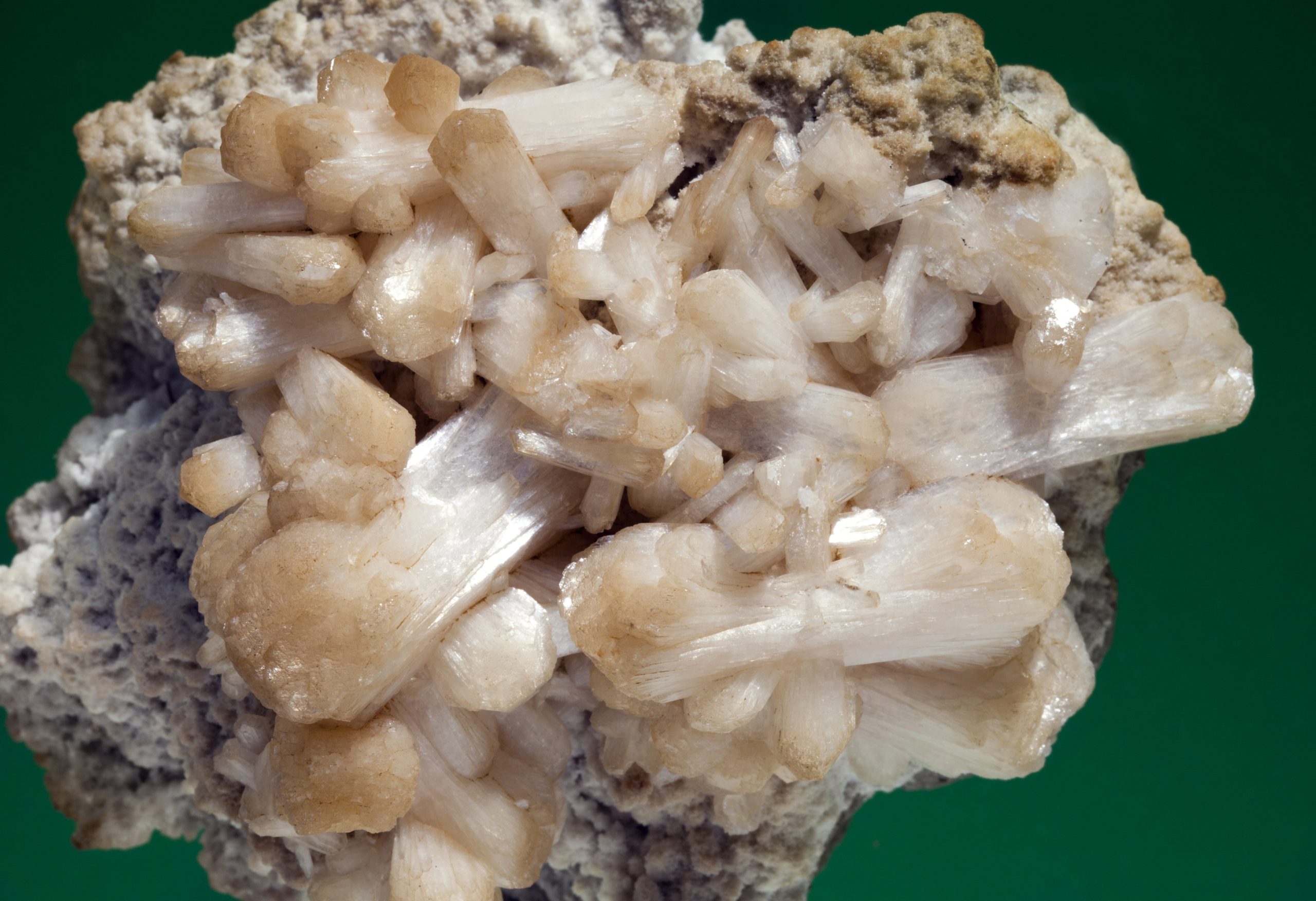
The secondary minerals have precipitated in cavities and fissures in the basalt, usually shortly after the eruptions, and are dominated by zeolites and quartz minerals. The zeolites are hydrous silicate minerals which have crystallised under relatively low pressure and heat. They are quite fragile, and the most spectacular examples are typically found in connection with tunnel work. The quartz minerals occur in different types, the most common of which is chalcedony. In addition, rock crystals, opal and jasper as well as other rarer types of quartz minerals are seen in both the basalt and the sedimentary rocks. Besides zeolites and quartz minerals, you can also find copper, pyrite and celadonite as well as various rarer minerals.
Between the basaltic lava flows you can find layers of sedimentary rocks, which, due to their volcanic origin, are collectively called volcaniclastic sediments. They consist of sandstone, siltstone and claystone as well as coarser conglomerates. The sediments often contain plant fossils, just as a single trace fossil has been found here. Together with the secondary rocks, you will often find hardened ash, also called tephra, as well as coarser volcanic explosive material such as lapilli and volcanic bombs.
Further reading
- Akraberg
- Hvannhagi
- Landscapes and coasts on the Faroe Islands
- Nature and environmental management
- Streams on the Faroe Islands
- The sea around the Faroe Islands
Read more about Nature and landscape on the Faroe Islands