BJARNE JAKOBSEN/BIOFOTO/RITZAU SCANPIX, 2013
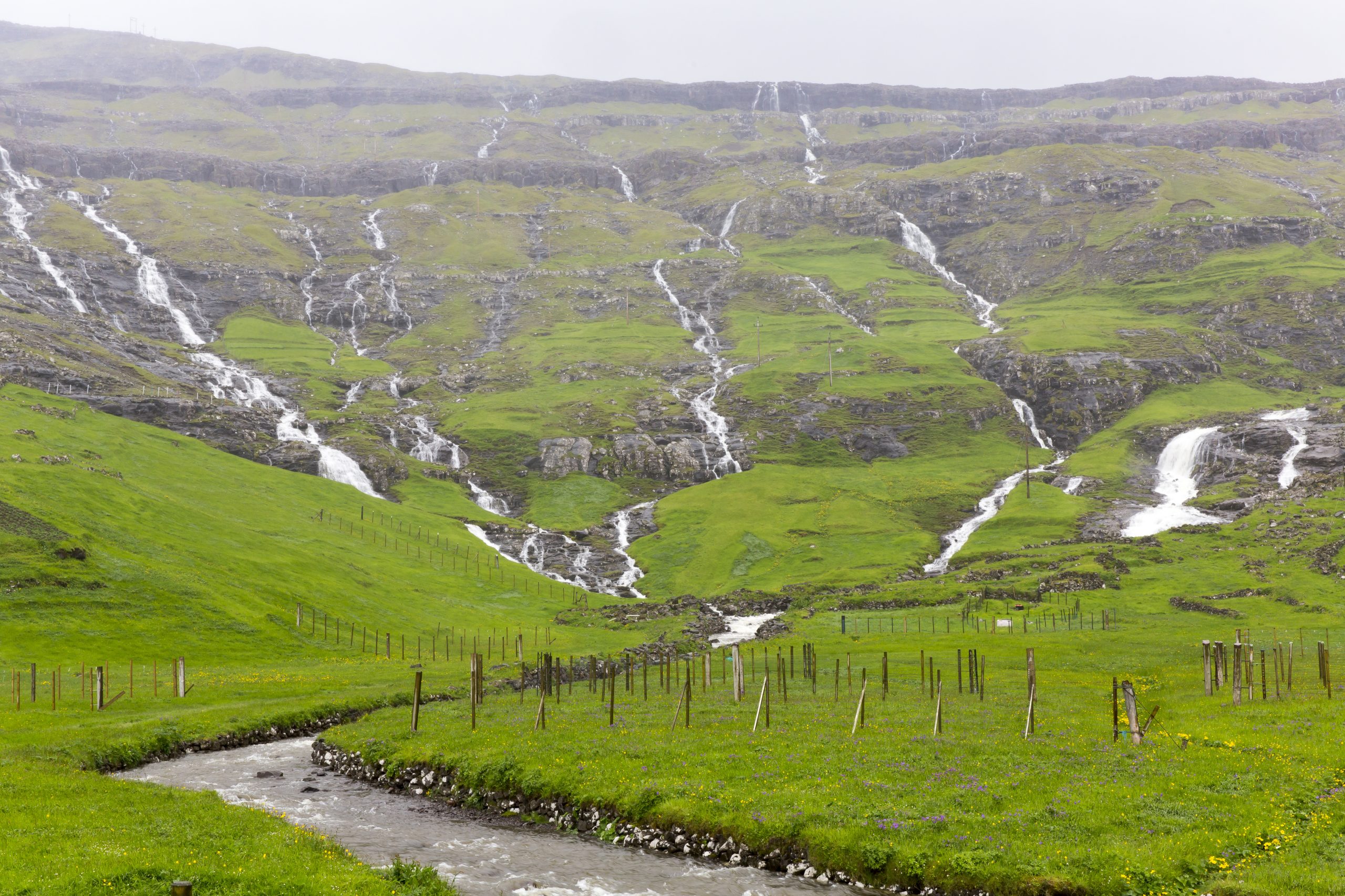
The Faroe Islands have around 1,200 streams, which with their associated tributaries have a total length of approx. 2,100 km. They are characterised by generally being short with modest water flow. Accordingly, an average Faroese stream is less than 1 km long and has a water flow of less than 70 l/s. However, these average values cover quite large differences. This is not least true when it comes to the water flow, which can vary significantly depending on the amount of rainfall. In Stóra at Hvalvík, the water flow can drop to approx. 500 l/s during dry periods, but can multiply to approx. 20,000 l/s after hours of rain.
SUNVA EYSTUROY, 2017
The longest stream is just over 7 km long. The stream rises in Loðadalur on Streymoy, from where it runs northeast. At Hóraldstoftarætt, it joins other smaller streams and continues southeast under the name Stóra. On its way towards the outlet in Hvalvík, it runs more or less parallel to the Saksunarvegur road.
The islands’ other long streams also include Sandá, which has its outlet south of the port in Tórshavn; Reyná, which originates at Úti á Dølum in Vestmanna; Kvígandalsá, which joins the Sjatlá stream at Vatnsoyrar; Heltná, which joins Skálafjørður, and Stórá, which has its outlet at Sandavágur.
The streams merge into large interconnected systems that drain large parts of the islands. The stream system with the largest catchment area begins in a brook in Kvígandalur on Vágar. On its way to Sørvágsvatn and on to the outlet at the sea through the Bøsdalafossur waterfall, it drains an area of more than 3,500 ha.
Another large stream system is the Reipsá, which is also the Faroe Islands’ widest stream. The stream system consists of several streams, which from their source in the mountains run to the Fjallavatn lake in the northern part of Vágar. In the north, Reipsá runs from the lake, and on its way to the sea, the stream reaches a width of over 30 m in some places. Shortly before it reaches its outlet at the Reipsáfossur waterfall, it is joined by Gullringsá, which has its source in the Hvilvtkinnavatn lake. On its path, the system drains an area of 2,700 ha.
The Leynará system on Streymoy also has a quite impressive catchment area of around 2,000 ha. It begins in Botn as the stream Dalá, which on its almost 5 km long route to the outlet at the northern end of Leynavatn is joined by countless smaller streams. Leynará runs from the lake in the south and continues for almost 2 km to the outlet at Leynar east of the Vága Tunnel.
Further reading
- Climate on the Faroe Islands
- Fens on the Faroe Islands
- Fresh Waters on the Faroe Islands
- Lakes on the Faroe Islands
Read more about Nature and landscape on the Faroe Islands